
Mesa Point Trail, located within the Petroglyph National Monument on the west side of Albuquerque, offers a short yet rewarding hike that blends natural elevation, volcanic geology, and ancient cultural elements. Though under a mile in length, the trail quickly gains elevation, giving hikers a unique vantage point over the city and the Rio Grande Valley. This trail is ideal for those seeking a physically engaging experience with interpretive value and scenic views.
The trail begins in the Boca Negra Canyon area, one of the most easily accessible sections of the Petroglyph National Monument. Boca Negra provides parking, restrooms, and a few other short trails, making it a convenient starting point for visitors who want to explore more than one path.
Mesa Point Trail is often a highlight for those stopping in this area, especially for first-time visitors interested in a hike that includes both cultural insight and an aerobic climb.
The trail begins in the Boca Negra Canyon area, one of the most easily accessible sections of the Petroglyph National Monument.
Boca Negra provides parking, restrooms, and a few other short trails, making it a convenient starting point for visitors who want to explore more than one path.
Mesa Point Trail is often a highlight for those stopping in this area, especially for first-time visitors interested in a hike that includes both cultural insight and an aerobic climb.
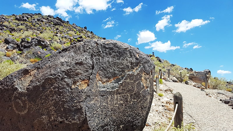
Mesa Point Trail is composed primarily of dirt and volcanic rock, a result of the area’s geological origins tied to ancient lava flows from nearby volcanic cones. The trail ascends a mesa through a rocky and rugged path, requiring sturdy footwear and careful footing. Though the trail is short, just about 0.6 miles round trip, it rises quickly, making it moderately challenging for its length.
Stone steps and uneven surfaces make it necessary to stay alert while hiking. The elevation gain rewards visitors with a sweeping view at the top, where panoramic perspectives of Albuquerque, the Sandia Mountains, and the Rio Grande floodplain unfold. The climb might be brief, but the reward is wide in scope.

Search all available homes for sale. View property photos, listing details, and schedule showings.
Along the trail, hikers will encounter petroglyphs, ancient images carved into the volcanic rock by the ancestral Pueblo people and early Spanish settlers. These etchings are protected, and while viewing is encouraged, touching is prohibited. Interpretive signs provide context, helping visitors understand the historical and cultural meaning behind these markings. Their presence adds a powerful, reflective dimension to the hike.
The best times to hike Mesa Point Trail are during the cooler months of spring and fall or early in the morning during summer. The open exposure means there is little shade, and temperatures can climb quickly. Sunscreen, a hat, and plenty of water are essential. While the trail is not long, its steepness and rocky surface make hydration and preparation important.
Pets are not permitted on the trail, and since this is a protected area, staying on designated paths is mandatory. The trail is well-maintained by the National Park Service, and signage is clear and informative throughout the hike.
Mesa Point Trail combines physical exertion, historical context, and geological curiosity in a condensed format that makes it a worthwhile visit for locals and tourists alike. Located within the Boca Negra Canyon section of the Petroglyph National Monument, it is one of the few trails in the area that delivers elevated views alongside ancient artwork. Whether you’re seeking an educational outing or a brisk uphill walk with a rewarding view, Mesa Point Trail presents an experience that remains memorable well after the descent.
From Unser Blvd NW and Montano Rd NW, head north on Unser Blvd to Atrisco Dr NW. Turn east on Atrisco Dr to the Petroglyph National Monument entrance. Continue right until you reach the trail parking lot.
GPS Coordinates: 35.16093, -106.71650

Whether you’re looking to buy vacant land, a home or simply curious what your property is worth in today’s market, we can help. You can call, text or e-mail us any time.
Call, text or e-mail us today: